SPOT
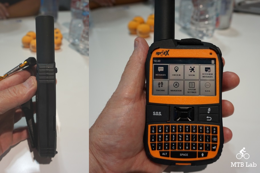
The SPOT X is a high-tech and functional 2-way satellite messenger, utilizing a QWERTY keyboard (ala Blackberry) for tracking purpose, messaging and SOS.
SPOT X provides 2-way satellite messaging so you can stay connected to family, friends, and colleagues whenever you’re outside of a cellular range, including direct communication with Search & Rescue services in case of a life-threatening emergency. SPOT X even provides you with your own personal mobile U.S. number so others can message you directly from their cell phone or other SMS devices at any time.

It retails for $249.99 and requires no annual commitment, and utilizes a flex plan (pay only when needed) or normal monthly plan at basic, advanced and unlimited levels.
It features the capabilities to message, track, compass, S.O.S, Post to Social and Check-In:
- Message – Exchange messages with any cell phone number or email address from virtually anywhere in the world.
- Tracking – Select from 2½, 5, 10, 30 or 60-minute tracking intervals, and let family, friends and other adventurers follow your progress with SPOT’s easy-to-use Google Maps interface.
- Compass – Built-in compass and programmable waypoints to help you navigate.
- S.O.S. – Send an S.O.S. to the 24/7 Search & Rescue center, message back and forth about the nature of your emergency, and receive a confirmation when help is on the way.
- Post To Social – Link your social accounts to keep your friends and family in the know wherever you go. Post to Social
- Check-In – Quickly and easily let everyone know you’re OK.
Features
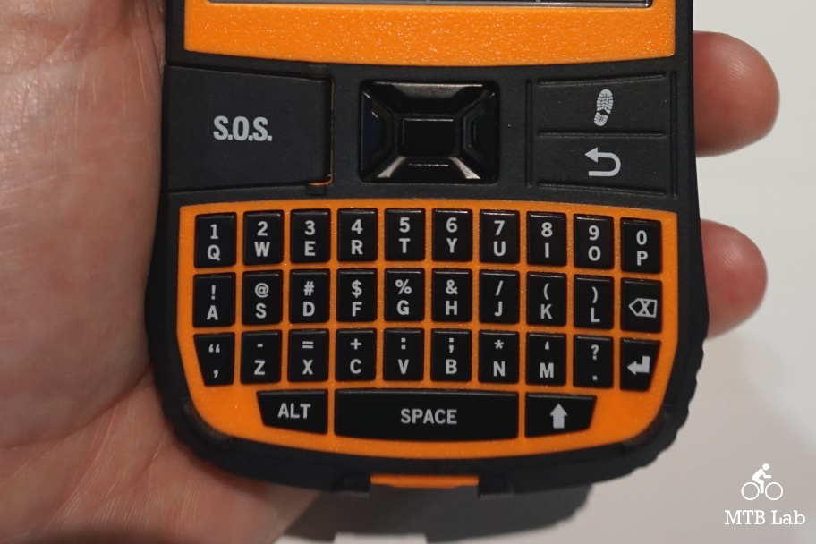
- Illuminated QWERTY Keyboard
- Tracking – 240
- Hours (10 Days) Of Battery Life In Continuous 10 Minute Tracking Mode
- Sos – Alerts 24/7 Search & Rescue Center
- Rechargeable Lithium Battery
- Lightweight
- Impact Resistant, Dust & Waterproof (Ip67)
- 2.7″ Backlit Display
- Micro USB Port
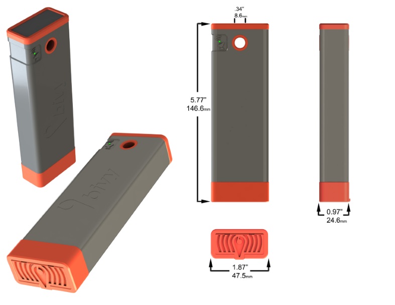
Bivy
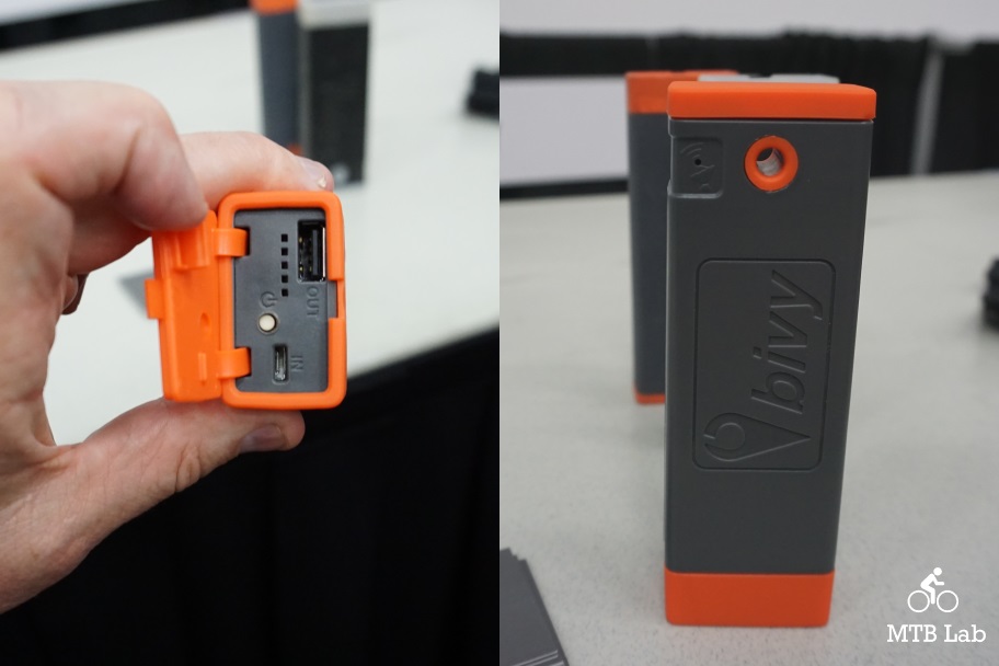
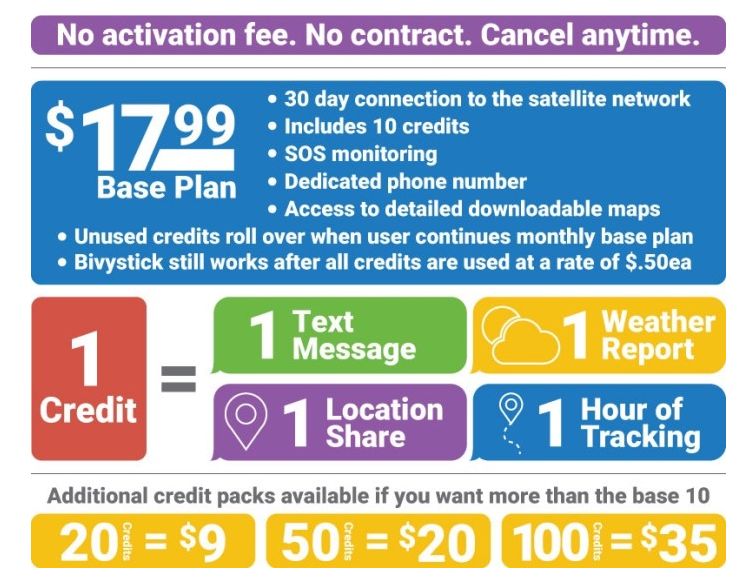
The Bivystick lets you turn your cell phone into a satellite communication device, and doesn’t require any contracts or activation fees, just buy credits as needed.
Bivy Stick gives you peace of mind when you are off the grid. Turn it on when you need it. No contract or activation fees. Use your cell phone to communicate via satellite when no phone service is available. Bivy Stick allows you to send and receive text messages, share your location, track your path, send an SOS message in case of emergency and access weather forecasts. All of this seamlessly integrated with Bivy App and it’s database of more than 40,000 trails, climbing routes and waterways. Plus keep your phone charged with the 6000 mAh back up battery so you can get that message out when needed. Not only will you feel safer while you explore new areas, your loved ones will sleep easily by keeping track of your location and status. It is the ultimate tool for the modern day adventurer. With Bivy Stick you Stay Safe and Found. The Retail Price will be $349 and it will be available to ship in September 2018.
- No contract or commitment. Activate it only when you need it. Bivystick uses a simple credit system to manage your data needs. To send one text message,
you need one credit. To pull one weather report, you use one credit. You purchase the amount of credits that you need for your style of adventure. - Send and receive text messages from anywhere in the world. All you need is a clear view of the sky and the Bivystick will connect to one of the 60+ satellites in the Iridium network.
- Share your location at any time. You can share your location via text message or social media (Facebook and Twitter)
- Track your path and share it with anyone you choose. Keep yourself and your loved ones aware of where you’ve been.
- Connects to your phone via Bluetooth or cable.
- Detailed Offline maps eliminate the need to carry a separate GPS unit
- SOS in case of emergency. Communicate with EMS to ensure proper and efficient rescue.
- Accurate point weather forecast at any time.
- 6000 mAh battery to keep your phone charged for an entire weekend adventure.
- Rechargeable via USB.
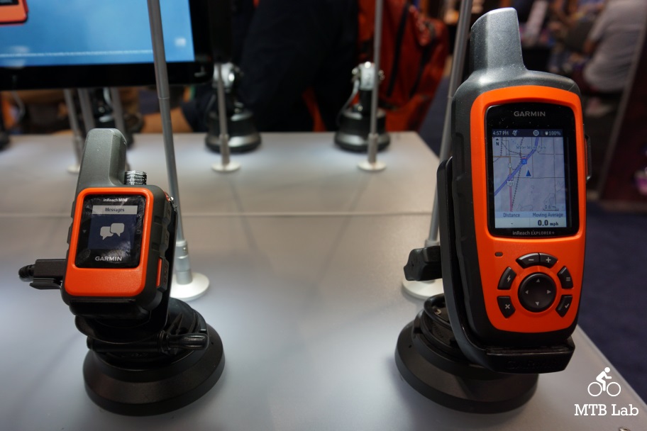
inReach Mini/ inReach Explorer+
Garmin
The Garmin inReach devices are handheld Satellite Communicators which can be used for both emergency SOS purposes for a rescue and have the ability to track and share your location with family and friends (electronic breadcrumbs).
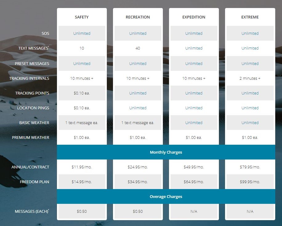
Each of the units requires a monthly subscription plan which includes either a Safety, Recreation, Expedition and Extreme service level with varying degrees of coverage.
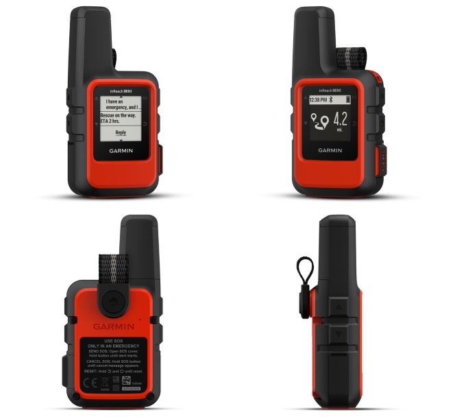
inReach Mini
Fit global connectivity in your palm with our smallest, lightest satellite communicator yet. Weighing a mere 4.23 oz, inReach Mini provides global messaging and interactive SOS plus basic GPS and compass page navigation. It can pair with a smartphone, tablet or compatible Garmin outdoor device to access topographic maps, aerial imagery, U.S. NOAA charts and other advanced features.
- Small, rugged, lightweight satellite communicator enables two-way text messaging via 100% global Iridium satellite network
- Trigger an interactive SOS to the 24/7 search and rescue monitoring center (satellite subscription required)
- Access downloadable maps, U.S. NOAA charts, color aerial imagery and more by using the free Garmin Earthmate app and compatible devices
- Optional inReach weather forecast service provides detailed updates directly to your inReach Mini or paired device; basic and premium weather packages available
- Send and receive inReach messages through compatible Garmin devices, including connected wearables and handhelds
- Internal, rechargeable lithium battery provides up to 50 hours of battery life in 10-minute tracking mode
- $349.99
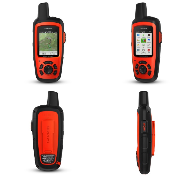
inReach Explorer+
Combining global satellite messaging with robust map-based outdoor navigation, inReach Explorer+ is our do-it-all performer. It provides GPS guidance with preloaded TOPO mapping viewable directly on the color display. A built-in digital compass, barometric altimeter, and accelerometer help you get and maintain accurate bearings, on or off the beaten path.
- Rugged handheld satellite communicators enable two-way text messaging via 100% global Iridium satellite network
- Trigger an interactive SOS to the 24/7 search and rescue monitoring center
- Track and share your location with family and friends
- Pair with compatible mobile devices using the free Earthmate app for access to downloadable maps¹, U.S. NOAA charts, color aerial imagery and more
- inReach Explorer+ device adds preloaded DeLorme TOPO maps with onscreen GPS routing plus built-in digital compass, barometric altimeter and accelerometer
- $499.99


{ 0 comments… add one now }