
Introducing: Surface Types
Paved or unpaved: know before you go!
Ride with GPS today officially unveiled their all-new web and mobile Surface Types feature, allowing you to see the road’s surface type as you plan, view, and navigate routes so that you can prepare for the road —or trail— ahead.
“Our mission is to help users go on better rides, more often. Knowing the surface type doesn’t just help route planners; it provides a better riding experience for everyone and encourages folks to discover more places to ride,” said Zack Ham, Ride with GPS founder.
“Especially with gravel riding being so popular, Surface Types helps users find the ride that they’re looking for — one with little pavement. The Surface Types feature is available on our web and app platform and breaks down the terrain by percentage, so you know exactly what you’re in for.”
Surface Types is the latest tool in the vast and exclusive Ride with GPS planning tool kit that already includes a heatmap overlay, satellite maps, and street view — leaving little room for questions as you head out on your adventure prepared.
Before You Go:
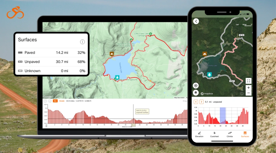
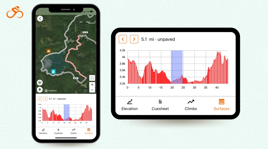
Web and mobile users will now distinguish paved roads from unpaved roads or trails while planning or viewing routes. This takes the guesswork out of route planning and ensures that you’re leaving the house prepared for what’s ahead and on the appropriate set of tires.
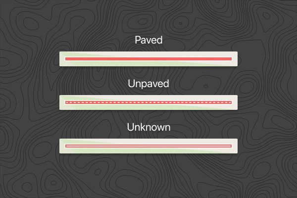
There are three surface type categories:
- Paved – Paved surfaces include asphalt, concrete, and chip seal. Paved surfaces are shown as a solid line.
- Unpaved – Unpaved surfaces include gravel, dirt, and natural/unimproved trails. Unpaved surfaces are shown as a dashed line.
- Unknown – When there is insufficient data available about a surface, it will show up as unknown. Unknown surfaces are shown as an outlined white line.
On The Go:
Viewing and navigating routes from your app? Route overview, route lines, and elevation profiles will now visually reflect the surface types of your route as outlined above. Likewise, surface types will appear as you plan your route using the mobile route planner as well. This way, there will be fewer surprises as you route a detour on the go!
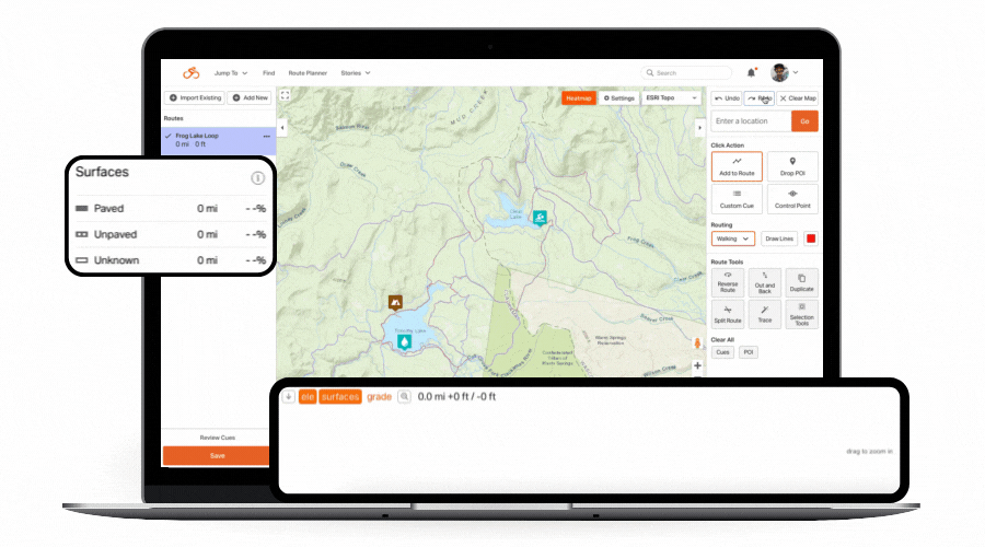
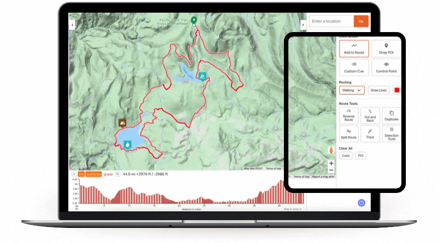
Web:
- Take the guesswork out of route planning to ensure that you’re leaving the house prepared for what’s ahead and on the appropriate set of tires.
- Surface type is visible when planning, editing, and viewing a route.
- Surface type categories are visible as a percentage breakdown of your total route and visually presented in the elevation profile and route line.
- If a user doesn’t like or want surface type information, they have the option of turning it off on the route line and/or elevation profile.
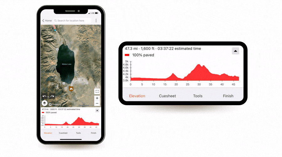
Mobile:
- On mobile, surface type info is available when planning, editing, and viewing routes, both in the route line and elevation profile.
- Surface type information is also visible when navigating your route
- When navigating, surface type transitions are shown in sections. One can toggle ahead between changing surface sections to explore what’s ahead.
- Plan a new route or edit your existing route on the go
Because you know your local roads best…
Like many other services out there, Ride with GPS relies on surface type data from OpenStreetMap (OSM), an open-source mapping service of the entire world. But we recognize that this data is incomplete, and our users riding those roads day in, day out knows best. Therefore, we’re the first route planning service to allow users to visually adjust the surface types of their personal routes using the Ride with GPS Route Planner. For permanent changes, we encourage users to contribute up-to-date surface types information to OSM as well.